|
|
 |
|
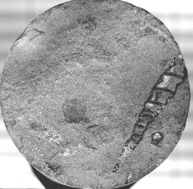
Photo of gastropod in core cut in Upper
Smackover, Baldwin County, Alabama
|
This
site built & maintained by
Vision
Exploration LLC
Comments?
Contact Us
©
Copyright 2017
Vision Exploration / MGS
All rights reserved |
|
|
3D and 2D Seismic Data Examples
Interested in learning about the
subsurface geology of Mississippi? Studying 3D and 2D
seismic data can provide a wealth of information about the
subsurface geology in an area of interest. Our thanks to
Seismic Exchange for providing the sample 3D and 2D lines shown on
the map and listed below. Click on the corresponding link to
view the seismic line.
Copyright
©
2017 MGS. All rights reserved.

Map
Showing Location of Seismic Data (3D Data - Black Squares, 2D
Data - Dark Blue Circles; Numbered for Reference)
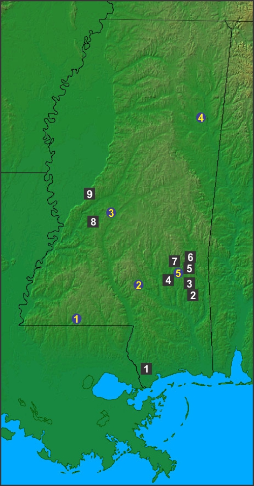
| 3D |
3D
Seismic Data - Sample Lines (Black Squares) |
| |
|
| 1 |
3D Dipline,
Hancock County (Wiggins Arch / Hancock Arch) |
| 2 |
3D Dipline,
So. Wayne County (Smackover / Norphlet Trend) |
| 3 |
3D
Dipline, Wayne County (Smackover / Norphlet Trend) |
| 4 |
3D Dipline,
Jones County (Eutaw / LT / Cotton Valley Trend) |
| 5 |
3D Dipline, No.
Wayne County (Smackover / Norphlet Trend) |
| 6 |
3D
Dipline, So. Clarke County (Smackover / Norphlet Trend) |
| 7 |
3D Dipline,
Jasper County (Eutaw / Cotton Valley Trend) |
| 8 |
3D Dipline, Hinds
County (Eutaw / Lower Tuscaloosa Trend) |
| 9 |
3D Crossline,
Yazoo County (Chalk / Eutaw / CV Trend) |
| |
|
| 2D |
2D
Seismic Data - Sample Lines (Dark Blue Circles) |
| |
|
| 1 |
2D Dipline, SW Mississippi (Lower Tuscaloosa Trend) |
| 2 |
2D Diplines, Interior Salt Basin (2 Lines - 2 Salt Domes) |
| 3 |
2D Dipline, North Flank Jackson Dome |
| 4 |
2D Dipline, Black Warrior Basin |
| 5 |
2D Dipline, SE Mississippi (Smackover / Norphlet Trend) |
|
|
|
|
|
|
|
 |
|
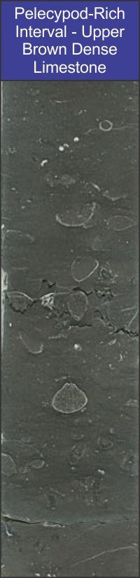
Core slab photograph of the pelecypod-rich
"A" interval of the Lower Smackover Brown Dense Lime (South
Arkansas) |
|
|
|
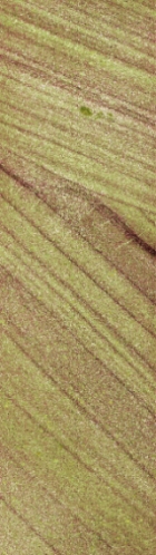
Eolian
cross-bedding seen in a diamond core slab taken from an 800' thick
Norphlet "seif" (linear) dune in Southeast Mississippi. |
|
|